HISTORY OF ELKINS
 Elkins, the county seat of Randolph County, is located on the upper Tygart Valley River, where the river flows to the northwest through a break between Rich and Laurel mountains. Elkins, elevation 1,930 feet, serves as a gateway to the Allegheny Mountains that lie to the east.
Thomas Skidmore (ca. 1733-1807), born in Maryland, obtained a title to 400 acres of land (“by virtue of a settlement”) in the future Elkins area before 1778. This land, on the east side of the Tygart Valley River, was surveyed by John Poage in 1780 and included the land that is now most of downtown Elkins. Thus, Skidmore was probably the first white settler in what became Elkins.
Before its major development, the area that would become Elkins was known as Leadsville, and was the site of a few scattered homesteads – a place where the local farmers’ corn crop was loaded onto boats and floated down the Tygart Valley River.
HISTORY OF THE RAILROAD
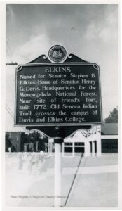
Elkins was founded in 1889, following the extension of the West Virginia Central & Pittsburg Railroad into Randolph County. Businessman Henry Gassaway Davis and his son-in-law, Stephen B. Elkins, purchased property near the village of Leadsville for the location of their headquarters and new railroad shops. The two founders developed railroad lines, coal mines, and timbering businesses. Elkins served as a railroad center for more than 75 years with the movement of coal and lumber by the West Virginia Central & Pittsburg, the Coal & Coke, the Western Maryland, the B&O, and later the Chessie System. Where the view of the new town was most delightful and picturesque, Davis and Elkins each built permanent places of residence, known as Graceland (1893) and Halliehurst (1890), respectively.
 Railroads played a vital role in the economic growth of Randolph County. Within a decade, major railroad extensions provided the county with a direct connection with the main line of the Baltimore & Ohio Railroad. This offered a nationwide market for the county’s abundant timber and coal. The Western Maryland Railway and the Chessie System continued to serve the county until the 1980s, when the CSX Railroad ended its service to the region. With the coming of rail transportation, mining Randolph County’s vast coal reserves became an important economic activity and remained so for many years. Coal production was 884,735 tons in 1920 and peaked at 1,237,000 tons in 1980, but had dwindled to practically nothing by 2004. In 2005, the county still had an estimated coal reserve of 2,416,000,000 tons. The West Virginia Railroad Authority now serves Randolph County.
Today, the Durbin & Greenbrier Valley Railroad operates scenic excursion passenger trains. From April through December, trains will pull in and out of the historic Western Maryland Depot located in Downtown Elkins.
COUNTY SEAT WAR
After an intense county seat war with nearby Beverly, where the new county courthouse building was burned down in 1897 under suspicious circumstances, Elkins became the county seat in 1899. This was resolved, however, only after multiple referenda, court judgments, and the mobilization of armed bands in both towns. In the end, bloodshed was averted.
In 1904 the new Randolph County Courthouse – designed in the Richardsonian Romanesque style – was completed in Elkins. As the railroad (merged into the Western Maryland Railway in 1905) expanded, Elkins experienced the luxury of passenger train service. In 1930, 18 passenger trains were arriving and leaving Elkins daily. All passenger service was discontinued in 1958.
REGIONAL AIRPORT
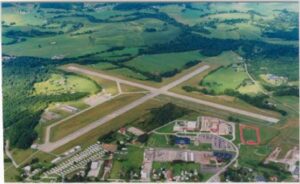 The Elkins-Randolph County Airport, constructed in 1934–35, served as a terminal for major and commuter airlines for a half-century and is now the home port for many private and corporate aircraft. In the early days of airmail services, mail was picked up by stringing a wire between two poles while an aircraft caught the wire on the hook as it flew overhead. The mail to be delivered was then dropped as the aircraft departed. During World War II the airport was used as a US ArmyCorps training base. The cadets were housed in Halliehurst Mansion at Davis & Elkins College. The airport was also used as an evacuation facility for east coast military bases during hurricanes. At those times the airport would be wingtip to wingtip with warbirds.
Being one of the early airways crossing the country, Elkins has seen a wide range of navigation facilities, beginning with the lighting of fire at night to guide pilots. Later, Elkins became a site on the Airway Beacon System (the last of which is still operated on Rich Mountain west of the airport). An automated flight service station operated by the U.S. government at the airport provides updates on weather and flight data for aircraft entering into the air space of West Virginia. The Elkins airport is currently served by several instrument approaches included three Global Positioning Systems (GPS).
DAVIS & ELKINS COLLEGE
Davis & Elkins College, founded in Elkins in 1904, was named in honor of its two patrons, Henry Gassaway Davis and Stephen B. Elkins. The college is a four-year liberal arts institution affiliated with the Presbyterian Church which accommodates students from many states and foreign countries. The Augusta Heritage Center, with offices at the college, offers popular annual workshops in folk music and the traditional arts. The Mountain State Forest Festival, the oldest festival in the state, has been held in Elkins since its inception in 1930.
OUTDOOR RECREATION DESTINATION
 The City of Elkins is considered the Base Camp of the Monongahela National Forest and a mecca for sportsmen and outdoor enthusiasts who visit the streams and forests in the area. Agencies of federal and state governments maintain a strong presence in Randolph County. The Monongahela National Forest, with almost 909,000 acres in ten West Virginia counties, is headquartered in Elkins. The U.S. Fish and Wildlife Service and the West Virginia Division of Natural Resources administer and provide research in managing game and wildlife in the region. Explore more of Randolph County’s outdoor opportunities.
HISTORIC CROSSROADS
Elkins is a historic crossroads. U.S. 33, which connects to Interstate 79 at Weston, intersects U.S. 219-250 in Elkins. U.S. 219 connects Elkins to Parsons in the north and Marlinton in the south. From Elkins, via Huttonsville, U.S. 250 crosses the mountain ranges to the southeast through Pocahontas County and Monterey, Virginia. U.S. 33, now a modern four-lane highway west of Elkins, crosses five mountains on its way eastward from Elkins by way of Harman into Pendleton County.
SOURCES
Holmes, Charles J. & Justin M. Kunkle, eds. Elkins, West Virginia, November Nineteen Six. Elkins: Board of Trade, 1906.
Rice, Donald L. Elkins Centennial Album. Parsons: McClain, 1990.
Rice, Donald L. Randolph 200: A Bicentennial History of Randolph County, West Virginia. Elkins: Randolph County Historical Society, 1987.
CITE THIS ARTICLE
Rice, Donald L. “Elkins.” e-WV: The West Virginia Encyclopedia. 30 May 2013. Web. 26 February 2022.
