Graham-Davis District
The Graham-Davis District is a national historic district located in Elkins, located south of the historic downtown. This area became a national historic district in 2021. This historic district encompasses 229 contributing buildings and 1 contributing object in a primarily residential section of Elkins. The district includes different achectectural style homes – Late Victorian, Queen Anne, Colonial Revival, and late 19th to early 20th century American movements.
The initial settlement of Randolph County was concentrated in the vicinity of Beverly, south of present-day Elkins, and dated from the late eighteenth and early nineteenth century. The area that would become Elkins began as the rural village of Leadsville, named for its proximity to the mouth of Leading Creek. By 1823 a post office was established in the settlement, although Leadsville’s growth was slow during the ensuing six decades and it remained little more than a rural hamlet. In 1888 Henry Gassaway Davis acquired 163 acres from Bernard Hinkle, a tract that would comprise much of the railroad yards to which the community’s fortunes would be inextricably linked. Davis (1823-1916) was a native of Woodstock, Maryland and at an early age began work as a brakeman on the Baltimore and Ohio Railroad. Prior to the Civil War, he began investing in coal and timber lands in the section of northwestern Virginia which would become West Virginia. In the 1880s Davis and his business partners constructed the West Virginia and Pittsburgh Central Railroad to access these vast natural areas, and among the communities which thrived along the line was Leadsville. In 1889 the village was incorporated under the new name of Elkins, honoring Davis’ son-in-law, Stephen Benton Elkins (1841-1911). Early in the 1890s, the WV&PC constructed massive railyards, repair shops, and a roundhouse (not extant) at Elkins. Railroad workers and their families were among the early residents of the Graham-Davis Historic District.
Elkins owed its earliest growth to the 1889 arrival of the railroad; that line would ultimately become part of the Western Maryland Railroad system and early settlers became known as “89ers.” Led by Davis and Elkins, the WV&PC extended south from Tucker County into Randolph County, where immense lumber, coal, and mineral resources were ripe for exploration. At the time of its charter, Elkins claimed a population of 349 that ballooned to 2,023 just ten years later, and by 1920 to nearly 7,000.
The area that would ultimately include the Graham-Davis Historic District was originally part of the holdings of George W. Ward (d. 1877), whose family controlled more than three hundred acres that encompassed significant portions of what would become eastern and southeastern Elkins. In 1868, George Ward’s son, Matthew (1850-1916), sold 158 acres to Lewis and Columbia Woolwine. Lewis Woolwine (b. 1840) was born near present-day Dailey, West Virginia and appeared in Census records as a farmer. He and his wife, Columbia White Woolwine eventually moved to Leadsville. In 1888, Woolwine sold thirty-six acres of his farm to Frank Graham and J. W. W. Davis who engaged surveyors to lay out what would be among the earliest expansions to the burgeoning Elkins, incorporated as a city the following year. A series of 50-foor-wide streets were laid out with sidewalks and typically long, narrow building lots.
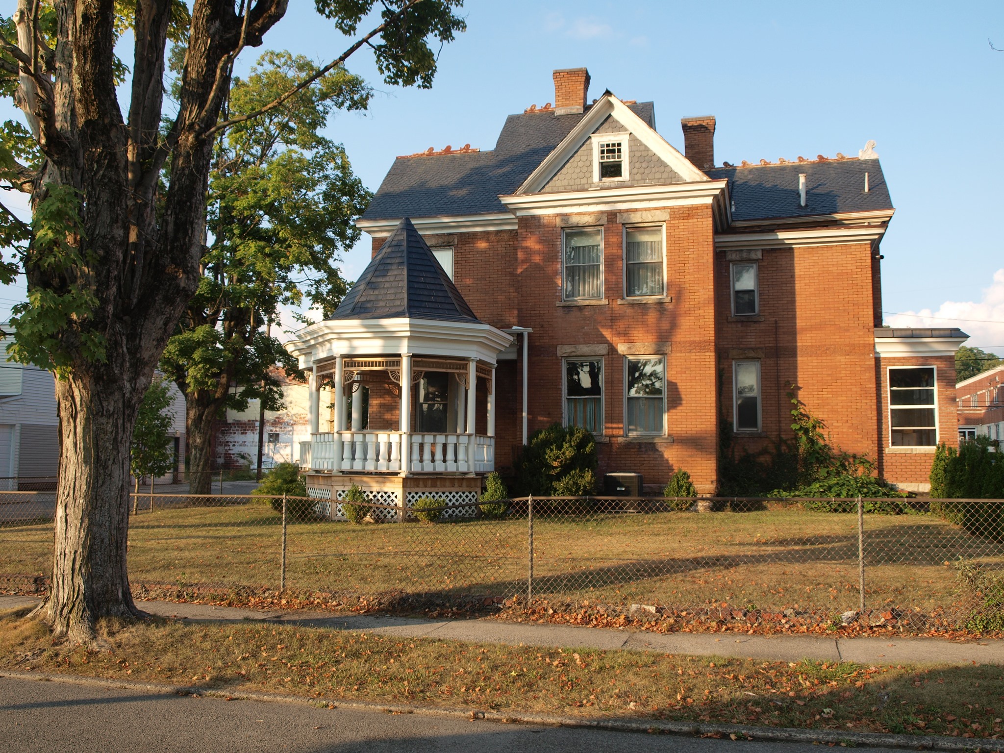
The area’s popularity was nearly immediate and by the mid-1890s the new streets were filling with workers’ homes, along with middle-class residences and more substantial homes of Elkins business owners and community leaders. Representative examples of business and community leaders who made their home in the district include lumber mill operator J. B. Moore (301 Davis Street), Henry Lewis Shaffer (201 Davis Street), a partner in Shaffer Brothers General Merchandise Co., Floyd G. Whetsell, a one-time sheriff and operator of the Barnard and Whetsell Block Co., manufacturers of concrete block, (516 Davis Street), Ray Bishop, a prominent builder-developer who also owned the Bishop Feed Store and the Bishop Planing Mill (124 S. Randolph Avenue), and architect/builder Eugene Liller (150 Delaware Avenue).
Workers who lived in the district include Eugene Thomas (517 Center Street), who was employed by Veterans Cleaners, carpenter C. D. Newton (141 Delaware Avenue), machinist Delbert J. Blackwood (102 S. Randolph Avenue), teacher Ruth Horsey (504 Center Street), and electrician’s helper H. B. Moore (300 Davis Street).
Randolph Avenue contains more substantial homes than most of those on the district’s interior, although many of those fell to commercial development and their sites are not included within the district boundaries.
The Graham-Davis Historic District’s Criterion A significance is due to its place as a planned community, evident in the early platting of the subdivision that comprises much of the district, including regularly-spaced lots with frontage of between thirty and forty feet and depths of one hundred fourteen to one hundred twenty feet (Fig. 1). Some lots, such as those along Randolph Avenue, were longer and backed up to an unnamed creek that has since been culverted, and some lots along the Tygart Valley River (named for pioneer settled David Tygart) were even more irregular in form.
The Graham-Davis District’s Criterion C significance derives from the presence of several architectural styles and house types that were popular during the Period of Significance and that, along with unified setbacks, garage styling and placement, and materials selection contribute to the district’s strong feeling of time and place. The district’s styles include the Italian Villa, Queen Anne, Colonial Revival, and Craftsman style, as well as the ubiquitous American Foursquare house type.
With regard to the styles seen in the district, the following can be said: at the beginning of the Period of Significance late in the nineteenth century, the Italian Villa style was fading, but among its physical characteristics is the presence of a tower or turret. It is seen in this district in the locally-distinctive Shaffer-Cunningham Graham House at 201 Davis Avenue, with an L-shaped façade, a wrap-around veranda, and a square 3-story tower in the angle of the ell.
The Queen Anne style came into vogue late in the nineteenth century, employing, among other features, a liveliness of profile and often a variety of surface finishes. Within this district, representative examples of the Queen Anne style appear in the c. 1908 Kump-Presyz House at 300 Scott Street, the Fox-Swisher-Martin House at 420 Davis Street, the Shomo-Cox House, 10 South Randolph Avenue, and the E. W. Channell House at 20 South High Street.
With the fervor of patriotism in the wake of the American Centennial of 1876 came a resurgence of interest in pre-Revolutionary American design. The Colonial Revival style drew upon eighteenth-century antecedents, sometimes with painstaking attention to detail and other times with only the occasional Colonial-era trim element affixed to an otherwise unremarkable building. This style also includes the Cape Cod style, 11⁄2 stories in height, side-gable-roofed, typically with gable dormers. Colonial Revival-style houses in the Graham-Davis Historic District include the 1916 Georgian Revival-style W. N. Snedger House at 26 South Randolph Avenue, the c. 1929 Guy Morrison House at 102 S. High Street, the Phares-Vanscoy-Scott House at 421 Center Street, the modest 3-bay c. 1935 house at 128 Delaware Avenue, and the c. 1948 red brick Cape Cod-style Robert Lytle House at 340 Graham Street.
As in virtually every neighborhood that developed during the first decades of the twentieth century, the American Foursquare appears throughout the Graham-Davis Historic District. Often interpreted as more of a house type than an architectural style and representing purely twentieth- century design, such houses are typically square or nearly so in form, generally with a hipped or pyramidal roof that is usually, but not always, penetrated by dormers. In this district, Foursquares are primarily of wood but occasionally appear in brick, and exhibit facades of two or three bays in width and have a porch, typically with a hipped roof. Some American Foursquares exhibit hipped or pyramidal roof forms with offset gablets on the façade. The 2013 survey of this neighborhood recorded 46 Foursquares, including the homes of H. C. Kesling, 406 Davis Street, T. B. Stickley, 120 S. Randolph Avenue , S. T. Simmons, 312 Graham Street, repetitive Foursquares with offset roof gablets at 309 and 313 Center Street, and repetitive Foursquares with original window-enclosed front porches at 317 and 313 Davis Street.
Twentieth-century domestic design in the Graham-Davis Historic District is also represented by Craftsman-style Bungalows, born of the American interpretation of the Arts-and-Crafts movement early in the twentieth century. Typically 11⁄2 stories in height, Bungalows characteristically incorporate a laterally-oriented gable roof which projects beyond the plane of the house, shielding a recessed front porch and is penetrated by one or more dormers, front and rear. Bungalows in the district include the 1920 A. H. Hunter House at 21 S. High Street, the c. 1923 Young-Maxwell House at 122 S. Randolph Avenue, the c. 1923 Smith-Bond-Perchan House at 23 S. High Street, and the c. 1936 Doppleman-Groves House at 44 South Randolph Avenue.
While the majority of the buildings in this district are residential in character, some historic commercial buildings remain along portions of Randolph and South Randolph Avenues. The most prominent of these is the Scott Building at 51-55 Randolph Avenue. 3- stories in height, this turn-of-the-century corner commercial building has seven storefronts and an angled corner and a prominent metal cornice. Other commercial buildings are found along S. Randolph Avenue and in the first block of Randolph Avenue north of Scott Street. They are typically two stories in height, of masonry construction, and housed a variety of commercial undertakings over the decades; all are contributing to the character of the district as a whole.
Many of the buildings in the Graham-Davis Historic District are vernacular in character, applying that term as it is defined above. However, the term is by no means a pejorative, particularly since, although architects were indeed responsible for a number of buildings in the district, so many buildings built here and nearly everywhere during the Period of Significance of this district reflect local building traditions and the skill of local builders rather than the work of formally-trained architects. Such houses include gabled ells, along with modest front- and side- gable residences.
The Criterion C significance is strengthened by the presence in the district of the work of several leading local architect/builders. Among these are Thornton M. Whiteman (1875-1966) who was a prolific builder who promoted himself as an architect although Census data record him as a carpenter and contractor. His career spanned decades throughout Elkins, and he was responsible for no fewer than twenty buildings in the district and numerous others throughout the community, as recorded in a monograph authored by his daughter. Eugene Liller was another architect/builder who made his home at 150 Delaware Avenue. Hosea Darby (1865- 1942) maintained his office at 201⁄2 High Street and was associated with the construction of the homes of Enoch Channell (20 High Street) and Dr. E. R. McIntosh (33 High Street). It should be noted that in all three of these cases, each practitioner was a builder who identified himself as an architect, rather than being formally-trained professionals.
Summarizing, the Graham-Davis Historic District retains integrity and is distinctive as a cohesive and strong concentration of locally-significant, primarily domestic architecture dating from the last years of the nineteenth century through the first sixty years of the twentieth.